WRTLHD Stock News

WRLTHD Stock News

WRLTHD News Feed

Showing posts with label WRLTHD Weather Alert. Show all posts

California freeway bridge collapses, blocking Ariz. traffic

LOS ANGELES (AP) -- An elevated section of Interstate 10 collapsed Sunday amid heavy rains in the California desert, injuring one driver, stranding many others, and halting travel for thousands by cutting off both directions of a main corridor between Southern California and Arizona.

"Interstate 10 is closed completely and indefinitely," said Terri Kasinga, spokeswoman for the California Department of Transportation.

A bridge for eastbound traffic about 15 feet above a normally dry wash about 50 miles west of the Arizona state gave way and ended up in the flooding water below, the California Highway Patrol said, blocking all traffic headed toward Arizona.

The westbound section of the freeway near the tiny town of Desert Center also closed. The roadway was intact but extremely undermined by flooding and could need just-as-extensive rebuilding, Kasinga said.

No timeframe was given for when either side would reopen as crews were diverted from other projects to examine the site.

"They won't even be able to begin assessing the damage until Monday," Kasinga said.

That means those seeking to travel between California and Arizona would be forced to go hundreds of miles out of their way to Interstate 8 to the south or Interstate 40 to the north.

Busy I-10 is the most direct route between Phoenix and parts of Southern California, including Los Angeles.

Transportation officials recommended travelers on the east side of the collapse use U.S. Highway 95 in Arizona to get to the other freeways, and that in California drivers use state routes 86 and 111 to get to Interstate 8 into Arizona.

One driver had to be rescued from a pickup truck that crashed in the collapse and was taken to a hospital with moderate injuries, the Riverside County Fire Department said. A passenger from the truck was able to get out without help and wasn't hurt.

Hundreds of other cars were stranded immediately after the collapse, but the California Highway Patrol was working to divert them in the other direction off the freeway and it wasn't clear if any remained, Kasinga said.

Pamala Browne, 53, and her daughter were driving from Flagstaff, Arizona to Palm Desert, California when they got stranded when the westbound lanes were shutdown.

"Oh my God, we are so stuck out here," Browne told the Desert Sun newspaper. "There's no end to the cars that are stuck out here."

The rains came amid a second day of showers and thunderstorms in southern and central California that were setting rainfall records in what is usually a dry month.

Rain fell Sunday afternoon in parts of Los Angeles County's mountains, the valley north and inland urban areas to the east. The city also was expected to get a late repeat of Saturday's scattered showers and occasional downpours as remnants of tropical storm Dolores brought warm, muggy conditions northward.

"We have a chance of some more heavy rain in LA County this evening, thunderstorms, lightning, possibly some localized street flooding," said National Weather Service meteorologist Joe Sirard.

The showers forced the Los Angeles Angels' first rainout in 20 years and the San Diego Padres' first rainout since 2006.

Saturday's rainfall broke records in at least 11 locations, including five places that had the most rain ever recorded on any day in July, Sirard said.

July is typically the driest month of the year in Southern California. Because of that, Saturday's 0.36 inch of rain in downtown Los Angeles exceeded the 0.24 inch recorded July 14, 1886, which had been the wettest July day in nearly 130 years.

The record is especially significant, Sirard said, because downtown Los Angeles has the longest recording climate station, dating back to July 1, 1877.

Saturday's storm brought flash floods and power outages and turned Los Angeles County's typically packed coast into empty stretches of sand when the threat of lightning forced authorities to close 70 miles of beaches.

Signs warned beachgoers to avoid storm drain flows into the ocean because of Saturday's sometimes heavy rain. The Los Angeles County Department of Public Health recommends people avoid swimming within 100 yards of a storm drain for 72 hours after heavy rain.

Warnings were also in place for high surf and strong rip currents on all south-facing beaches, including Venice, Santa Monica, Malibu, Zuma, Newport and Huntington, officials said.

Meanwhile, the summer storm has helped firefighters advance on two wildfires that broke out Friday.

Muggy, moist conditions were expected to persist through Monday.


FOOT OF SNOW IN HAWAII!


CHILLWatch: FOOT OF SNOW IN HAWAII! The National Weather Service has forecast the temperature could reach around 54 degrees in the upcountry Kula area with a low of 59 degrees in the lower central Maui region. WINTER STORM WARNING has been issued for the Big Island of Hawaii on the summits of Mauna Kea and Mauna Loa above the 12,000 foot level till 6:00am Thursday. Snow could drop up to 10 to 15-inches.

Temperature factor at sea level for Hawaii:
70s Cool
60s Cold
50s Chill
40s Freezing (Big Island)

#mauiwatchweather #HawaiiNews #HINews #808News #HINewsMaui
See what MAUIWatched today on mauiwatch.com

'Crushed With Snow': 'Historic' Blizzard to Bomb Northeast


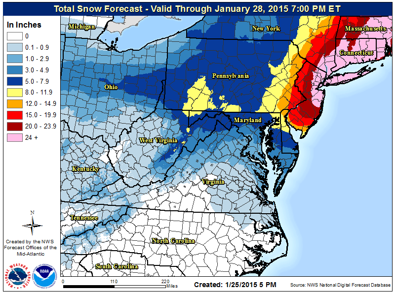
The New York City area was placed under a 35-hour blizzard warning beginning Monday afternoon, with more than 2 feet of snow expected to create "paralyzing, crippling" conditions, forecasters said Sunday. It's part of a storm system that's expected to pummel the Northeast from Philadelphia all the way to northern New England with potentially "historic" snow accumulations well into Tuesday night.

The National Weather Service estimated that 29 million people will come under the blizzard warning, and more than 3,100 flights scheduled for Monday and Tuesday were canceled in advance. The worst of it will be late Monday through Tuesday night, with blizzard conditions, damaging wind gusts to possibly hurricane strength and coastal flooding, the National Weather Service said. The nation's largest city was put under an extraordinarily long blizzard warning stretching from 1 p.m. Monday to midnight Tuesday.

The forecast means New York City could smash its one-day snowfall record — 26.9 inches, recorded in Central Park in February 2006.

"Very highly populated areas of the Northeast are going to get crushed with snow," said Tom Moore, coordinating meteorologist for The Weather Channel. "Everywhere ... you're going to get hit very hard by this storm."

"This could be the biggest snowstorm in the history of this city," Mayor Bill de Blasio told reporters Sunday. "My message for New Yorkers is prepare for something worse than we have ever seen before."

Confidence is increasing on a historic winter storm across parts of the Northeast Monday night thru Tuesday night, tapering off Wednesday morning. Blizzard warnings have been issued along the Eastern Seaboard from central New Jersey north through the New York City metro area and northeast across Connecticut, Rhode Island, eastern Massachusetts, and coastal New Hampshire and Maine. Snowfall rates of 2-4 inches per hour are expected, resulting with snowfall totals of 18 to 30 inches, with locally higher amounts. In addition very heavy snow, strong winds in the Blizzard Warning area are expected to gust to 35 to 50 mph, with gusts as high as 65 mph possible across eastern Long Island and Cape Cod. The heavy snow and blowing and drifting snow will reduce visibilities to near zero, making travel extremely dangerous. Snow drifts may exceed 3-4 feet across the blizzard warning area.

The strong northeast winds will create a storm surge along the coast. Moderate coastal flooding, especially during high tides is possible along the coast from Delaware Bay north all the way to the Maine coast. Major coastal flooding is possible along east facing sections of the Massachusetts coast. The strong winds will also create high waves that will likely result in significant beach erosion, as well as splash-over that could result in damage to waterfront structures and closures of shoreline roads.

Some uncertainty remains regarding how far west the heavy snowfall will get. That is why there is an area of Winter Storm Watches from Delmarva north across eastern Pennsylvania to the western Catskills and north into northern Vermont. Forecast confidence across this area is less than the area of Winter Storm Warnings further east.


Britain's winter storm: 100-mph winds, heavy snow, 149 flood alerts

(Peter Morrison / AP)
LONDON (AP) -- Britain and Ireland have been battered by 100 mph winds and heavy snow, stranding some motorists after a major road was closed.
The Environment Agency said Thursday that 149 flood alerts and 32 flood warnings had been issued in England and Wales, with more reported in Scotland.
Heavy weather and high seas also hit Northern Ireland.
Some of the most severe problems took place in Scotland where drivers on were stranded overnight on a highway by heavy snow.
Hundreds of homes were left without power.
In Dublin, airport officials said a number of incoming flights were diverted to other airports because of high winds. Travelers were advised to check their flight status before going to the airport.

Ana's advance slows as storm grows


Weather loop image

By Craig Gima
Hurricane Ana further intensified this afternoon with winds around 80 mph as it approached Hawaii.

At about 5 p.m., the storm's winds held at 80 mph, slightly above the category 1 hurricane status of 74 mph winds. The storm was 185 miles south-southwest of Kailua-Kona, and 310 miles south-southeast of Honolulu, moving to the west-northwest at 13 mph. The tropical storm force winds extend 105 miles — 20 miles farther out than earlier Friday afternoon — from the center and hurricane force winds extend out 25 miles. 

The storm is expected to pass 150 miles southwest of the Big Island Friday night and about 175 miles southwest of the rest of the island chain this weekend. The storm is also expected to take more of a northwest turn — closer to Hawaii — Friday into Saturday and slow down as it passes south of Oahu and Kauai Saturday night and Sunday.

Hurricane Ana could continue to strengthen Friday night before windshear gradually weakens it Saturday and Sunday.


"The window for intensification will close on Saturday," forecasters said. "But Ana will remain a dangerous tropical storm."

A tropical storm watch and flood watch is in effect for the Big Island. Forecasters expect heavy rains with the chance of thunderstorms, gusty winds, and rough surf as the storm passes the island Friday night.

The National Weather Service also posted tropical storm watches for Oahu, Maui and Kauai counties and surrounding waters.

Forecaster said the storm should be far enough south that winds will not reach tropical storm strength on the main Hawaiian islands. 

But, they caution that "only a small change in the track of Ana could result in higher winds on Saturday. ... It is still too soon to try to nail down details."

All islands will get high, rough surf on southern shores. Gusty winds that could down trees and cause power outages, and heavy rains with the potential for flooding and mudslides are also possible.

The storm will pass closest to Maui County on Saturday and should move south of Oahu Saturday night. Kauai will see the storm's greatest impact on Sunday.

The storm could dump up to 12 inches of rain in some areas of the Big island. But most areas should see 6 to 8 inches. Surf of 10 to 12 feet from the storm was reported at South Point Friday and foreasters expect waves of up to 20 feet in Kau and Puna as the storm makes its closest pass to the island. The Kona Coast could also get 12-foot surf after the center of the storm moves west.

Oahu and Kauai County may also see 10 to 20-foot wave faces on Saturday on south shores and 3- to 7-foot surf on west and east shores. A northwest swell is also arriving, boosting north shore surf to 10 to 15 feet Saturday into Sunday.

South shores of Maui County could see 10- to 15-foot surf Saturday and Sunday.

The 11 a.m. forecast track puts Ana's path further south, with all islands except Niihau out of range for a direct hit. 

But foreasters caution that people should not focus on the exact track of the storm.

"Only a slight shift to the right (closer to the Hawaiian islands) in the forecast track could mean signficant differences in the potential impacts to the main Hawaiian islands," forecasters said.

A high pressure ridge developing near Oahu and Kauai is likely to cause Ana to slow down and turn to the west, keeping the storm south of the islands.

But if the storm slows or stalls, the potential for more rain increases.

"The timing and extent of this turn has significant implications as to the potential impacts in the islands this weekend," foreasters said.

As of Friday morning, forecasters predicted some areas of Maui, Kauai and Oahu could get up to 8 inches of rain over the weekend. Most areas of Maui County should get between 2 to 4 inches and 3 to 6 inches could fall on Oahu and Kauai.

The forecast for southern shores of Oahu, including Honolulu, calls for a 50 percent chance of rain and potentially heavy rain, including thunderstorms Friday afternoon into Friday night as Ana's outer rain bands reach the island.

Saturday will bring frequent showers and the chance of thunderstorms through Sunday. Winds of 20 to 25 mph, with 35 mph gusts are possible through Sunday night as Ana passes south of the island. The chance of rain is 90 to 100 percent through Monday.

Maui and Kauai counties can expect similar weather, with the timing sooner for Maui and later for Kauai, as Ana makes its closest approach to those islands.

Ana will likely leave muggy Kona weather and showers in its wake as it moves northwest away from the state. The humidity and rainy weather could stick around through the middle of next week.

National Weather Service meteorologist Eric Lau said the winds can still down power lines and cause a lot of damage and rains, especially if they stall, could create flooding. The storm surge can also cause damage along the coast.

"Even a 40 mph wind is pretty strong," Lau said. "Torrential rains would be cause for flash flooding, especially for people in low-lying areas."

The weather service and civil defense officials say people should have their emergency kits stocked and be ready for the storm.

"People should be prepared for potential impacts," Lau said. "It could potentially be a dangerous storm."

Vongfong Weakens; Dozens Injured, Evacuations Advised After High Winds, Rain Lash Okinawa

UPDATE
weather.com


As of 11 p.m. EDT on Saturday, Vongfong was downgraded to a tropical storm. 
Just days after Typhoon Phanfone left three American servicemen dead on Japan's Okinawa Island, Typhoon Vongfong battered its shores once again with ferocious winds and drenching rain before weakening overnight on Sunday local time. At least 31 people were injured in the storm, according to Japanese News Network NHK. 
About 50,000 American troops are stationed in Japan, and nearly half of them are on Okinawa at Kadena Air Base, the Associated Press reports. 
NHK reported that 53,000 households in Okinawa and more than 50,000 in Kagoshima were experiencing blackouts as of Sunday morning. Authorities also advised the evacuation of 90,000 households in Okinawa and 2,700 in Kagoshima Prefecture due to the possibility of flooding and mudslides. 
On Saturday, huge waves lashed the shores of Okinawa as the initial rain bands of the storm moved ashore. A man in his twenties had his fingers severed when high winds slammed a door shut. Several elderly people In Okinawa City and Uruma sustained injuries in falls, according to the Okinawa Times. More injuries were reported in Ginowan, Yomitanson and Yaese-cho. 
Officials at Kadena Air Base raised the Tropical Cyclone Condition of Readiness, or TCCOR, to level 1. All non-emergency personnel will remain inside until the storm has passed, according to a post on the air base's Facebook page.
According to Stars and Stripes, servicemen and women at Kadena Air Base were told to discontinue all outdoor activities with Vongfong nearby. Many base facilities have closed to hunker down for the storm, the report added.
Areas of Japan have received massive amounts of rainfall in past months, and the slow, plodding nature of Vongfong could raise the risk of deadly landslides and flooding yet again, Reuters added.
Preparations took a serious tone after last week's tragedy on the base. Three airmen were killed by the raging seas off the coast of Okinawa in the wake of Typhoon Phanfone. The bodies of all three men have been recovered.

UPDATE:
Japan's Ryukyu Islands, including Okinawa, were still getting hammered by heavy winds before the storm's eye passed over. At least 22 people were injured late Saturday night (Saturday morning ET) by winds that reached 100 miles per hour in areas over Okinawa, according to Stars and Stripes. About 25,000 American troops are at Okinawa's Kadena Air Base, which raised its tropical cyclone readiness to a level 1 — meaning all service members should stay inside, according to a post on the base's Facebook page. Three American servicemen were killed in Okinawa Sunday when they were washed away while taking photos during Typhoon Phanfone, which made landfall as a Category 1.
The eye of Vongfong was 40 miles southeast of Okinawa, moving north-northwest at 10 mph at 11 a.m. ET Saturday, according to the U.S. military's Joint Typhoon Warning Center. When the storm passes over Okinawa, it is expected to bring relentless winds and rain, and likely produce flash flooding and mudslides in an area already over-saturated by Phanfone, according to Weather.com. Winds are expected to surpass 125 mph — the strongest measured at Kadena Air Base since 2009, Weather.com reported.

US Air Force Base in Super Typhoon's Path

NBC NEWS
         

The Most Powerful Storm on Earth This Year Is Heading for Japan

UPDATE OCT 8, 2014
by Andrew Freedman

Super Typhoon Vongfong has intensified further, with maximum sustained winds of about 180 miles per hour and gusts higher than 200 miles per hour. This puts it among the strongest storms on record, based on a satellite estimate.
Super Typhoon Vongfong is now equivalent to a high-end Category 5 storm, and it is forecast to intensify further during the next six hours, until it has winds of about 195 miles per hour, according to the Joint Typhoon Warning Center. By some measures it is equivalent to, if not slightly stronger than, Super Typhoon Haiyan, which devastated the Philippines in 2013. Its perfectly symmetrical satellite appearance is the sort that weather geeks the world over use as their screensavers.
Super Typhoon Vongfong has reached meteorological perfection, and hence peak destructiveness, as it churns across the warm waters of the Western Pacific Ocean toward Japan.
The storm intensified overnight into the equivalent of a strong Category 4 hurricane on the cusp of Category 5 status, with maximum sustained winds of at least 155 miles per hour. Super Typhoon Vongfong is heading for Japan, which is still recovering from Typhoon Phanfone over the weekend.
A one-two punch of typhoons, coming in a season that has battered Japan with several other intense storms, could result in severe, life-threatening flooding and mudslides, depending on Super Typhoon Vongfong's ultimate track and intensity as it approaches on Sunday and Monday. Due to cooler ocean temperatures and stronger upper atmospheric winds, it is highly unlikely that Vongfong will still be this powerful when it strikes Japan.
Vongfong Moonlight


Image of Super Typhoon Vongfong using NASA’s Visible Infrared Imaging Radiometer Suite (VIIRS), which shows the storm illuminated by moonlight.
IMAGE: NOAA/NASA/RAMMB/CIRA
But based on satellite imagery, Vongfong has reached an intensity level that few storms on Earth ever achieve, and it may still be intensifying slightly. It is likely to reach high-end Category 5 intensity, with sustained winds of greater than 155 mph, on Tuesday.
Vongfong is also the most powerful storm on the planet this year, based on estimated minimum central air pressure (the lower the pressure, the stronger the storm). By that metric, it could approach the intensity of Super Typhoon Haiyan, which decimated parts of the Philippines in 2013.
Vongfong Rainbow
Computer model projections show that the storm, which is currently moving west over the open waters of the Western Pacific Ocean, will make a sharp turn to the north and northwest late this week, while slowing down in forward speed. It will begin weakening as it moves closer to Japan, according to the Joint Typhoon Warning Center, but the forecast track takes it near or over mainland Japan, including major cities such as Tokyo.
Computer Models

Computer model ensemble projections for Super Typhoon Vongfong. Each track represents a different model run with slightly different initial conditions fed into the model.
IMAGE: WEATHERBELL ANALYTICS
Considerable uncertainty exists regarding the storm's track and intensity several days in advance, but computer models in the last few days have consistently been predicting either a very close call or a direct hit on Japan. In fact, the predicted path is extremely similar to Typhoon Phanfone, which brought 70 mph winds to Tokyo.
Vongfong CIMSS
If the storm does strike Japan, the biggest threat it will pose will come in the form of water. Parts of Japan received up to two feet of rain from Typhoon Phanfone over the weekend, and two other typhoons that have hit this year also dumped copious amounts of rainfall. Given that Japan is a mountainous country, there could be a high danger of mudslides along mountain slopes.
The Western Pacific has spawned four super typhoons so far this year, each with sustained winds at or greater than 150 miles per hour. The other storms were Super Typhoons Halong, Rammasun, Phanfone and Neoguri. Of those four, three of them — Halong, Neoguri and Phanfone — went on to strike Japan, albeit in weaker form.
The storm activity in the Pacific, both the western and eastern parts of the ocean, contrasts sharply with the Atlantic Ocean, which has been in a state of hibernation for much of this hurricane season.

Super Bowl Snowstorm? One Model Suggests Something ‘Major’ On Way


NEW YORK (CBSNewYork) – Don’t worry. At least not yet.
But one early weather projection is taking shape for Super Bowl weekend — and it doesn’t look good.
CBS 2 meteorologist Lonnie Quinn says one model suggests a system similar to this week’s snowstorm could hit the Tri-State area “within 48 hours” of Super Bowl XLVIII.
“If that holds true, this is a major player,” Quinn said on Wednesday night’s newscast, shortly after sharing the forecast with Mike Francesa on WFAN radio. “Not a small snowstorm, it would be a major player.”
Watch the video above for Quinn’s breakdown of the model.
The game between the Denver Broncos and Seattle Seahawks is scheduled for Feb. 2 at MetLife Stadium in East Rutherford, N.J.

Quinn, who’s known for rolling up his sleeves during bad weather, joked on Twitter that if the projection holds true, he may deliver next week’s Super Bowl forecast shirtless.
“One is, I’m not sure how reliable forecasts are this far out,” Goodell said in a New York Daily News interview. “And two is, we have a whole group of people that are getting the best information, have the right team together, to make sure we have appropriate information at the right time. There’s nothing I can do about that. Our team has been working to be prepared for all alternatives and I’m confident they will be.”
“We’re running ourselves through a rigorous dress rehearsal,” said NFL executive vice president Eric Grubman.
The NFL could move the big game to Saturday or even Monday or Tuesday if a major storm slams the area.